Historic Lake District Village Resurfaces at Haweswater: Mardale Green Emerges in 2026
Mardale Green, a historic Lake District village submerged since the 1930s, has resurfaced at Haweswater Reservoir in March 2026 due to exceptionally low water levels.
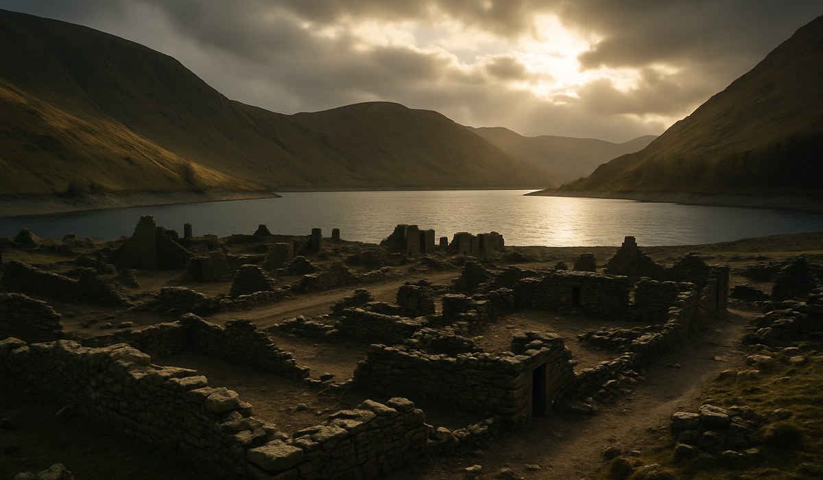
Image generated by AI
Falling water levels at Haweswater Reservoir in England's Lake District have exposed the stone remains of Mardale Green, a historic Lake District village deliberately flooded in the 1930s to supply water to northwest England. The village resurfaces in March 2026 as drought conditions push the waterline to unusually low levels, revealing building foundations, dry stone walls, and bridge abutments that have remained submerged for nearly nine decades. Visitors can now walk across former village streets and see the physical layout of a community sacrificed for urban water security.
Rare Exposure Reveals Scale of Drowned Mardale Green Village
The current exposure at Haweswater Reservoir presents one of the most extensive views of Mardale Green's remains in recent years. Dry stone walls trace the boundaries of former farmsteads, while bridge abutments mark where the old village bridge once crossed what was then a natural stream. Field systems and trackways become visible at particularly low water points, allowing visitors to map the three-dimensional structure of the settlement that occupied this remote Cumbrian valley until 1939. Local heritage organizations report that exposed sections include recognizable street patterns and building foundations that demonstrate the village's scale before inundation. The Lake District National Park Authority confirms that Haweswater's current level ranks among the lowest recorded in the past decade, creating optimal conditions for exploring this submerged landscape.
Manchester Corporation Flooded Valley in 1930s Water Scheme
Mardale Green stood at the head of the Mardale valley until Manchester Corporation identified the site as a solution to growing water demand from industrial cities in northwest England. Parliamentary approval in 1929 authorized construction of a concrete dam that raised water levels approximately 30 meters above the natural lake. The dam's completion in the mid-1930s submerged the entire village including farms, homes, the Dun Bull Inn, and the valley church. Historical records from the National Archives document that church stone and windows were salvaged for reservoir infrastructure, while graves from the churchyard were exhumed and reinterred at Shap, six miles to the northeast. By 1939, the last residents had departed and Haweswater became fully operational, supplying substantial volumes of drinking water to Manchester, Salford, and surrounding areas—a role the reservoir continues today.
Haweswater's Drowned Landscape Emerges During Drought Years
Mardale Green has surfaced during previous drought episodes, including severe dry spells in the 1970s and more recent low-water years in the 2010s. Each exposure reveals different degrees of the village fabric depending on how far reservoir levels drop. Stone field boundaries, gateposts, and the alignment of the old village bridge appear most frequently when waters recede. In some episodes, former lanes become clear enough to follow their course across the reservoir bed, transforming the site into a temporary open-air museum of pre-reservoir rural life. Climate data from regional water resource reports shows that Haweswater serves as a sensitive indicator of prolonged dry weather across the Lake District. Shifting precipitation patterns may increase the frequency of low reservoir levels, making temporary reappearances of drowned landscapes such as Mardale Green more common in coming decades.
Key Facts About Mardale Green Resurface Event
| Aspect | Details |
|---|---|
| Reservoir location | Haweswater, Cumbrian Lake District, northwest England |
| Village submerged | 1935-1939 following dam completion |
| Water level rise | Approximately 30 meters above natural lake |
| Original population | Fewer than 100 residents in valley farms and hamlet |
| Structures now visible | Dry stone walls, bridge abutments, building foundations, field boundaries |
| Previous major exposures | 1976, 1984, 1995, 2018, and current 2026 event |
| Current reservoir capacity | Supplies northwest England including Manchester metropolitan area |
Tourism Interest Draws Visitors to Remote Cumbrian Site
The 2026 resurfacing has attracted hikers, photographers, and history enthusiasts to Haweswater, a quieter corner of the Lake District compared to more popular destinations such as Windermere or Ambleside. Many visitors seek to compare the exposed remains with historic photographs taken before inundation, while others document the village layout using aerial drones and mapping applications. Conservation bodies remind visitors that exposed structures are fragile and form part of a protected historic environment. Guidance for low-water events advises staying on established paths and exercising caution around soft, silty ground at the water's edge. United Utilities, which operates Haweswater as a strategic asset, emphasizes that the reservoir remains active and that water levels can change even during dry periods, requiring visitors to respect restricted areas around infrastructure.
What This Means for Travelers
-
Plan visits soon: The exposed village remains visible only while low water conditions persist; sustained rainfall will gradually submerge structures again, potentially within weeks.
-
Access via Haweswater Hotel: The village site lies along the eastern shore road from Bampton to the reservoir head; parking is available at Haweswater Hotel car park and the dam area.
-
Respect heritage structures: Do not climb on or disturb exposed walls and foundations; these are protected archaeological features and fragile after decades underwater.
-
Combine with valley walks: The High Street ridge walk and Riggindale paths offer elevated views over the reservoir and resurfaced village layout.
-
Check water level updates: United Utilities and Lake District National Park social channels provide current reservoir level information to help time visits for optimal viewing conditions.
FAQ
How long will the historic Lake District village remain visible at Haweswater? The duration depends on rainfall patterns across the Lake District watershed; typically, exposed village remains disappear within two to six weeks once sustained precipitation returns. Water levels in March 2026 are exceptionally low, but spring storms can rapidly refill Haweswater, submerging Mardale Green again. Travelers planning visits should monitor regional weather forecasts and reservoir level data from United Utilities to maximize chances of seeing the site.
Can visitors walk on the exposed historic Lake District village ruins? While visitors can approach the exposed areas during low water, conservation guidance strongly advises against walking directly on fragile stone structures. Dry stone walls and building foundations have been weakened by decades of submersion and erosion. The Lake District National Park Authority recommends viewing ruins from established paths along the shoreline and treating the site as a protected archaeological landscape. Soft, unstable sediment around the water's edge also presents safety hazards.
Which other drowned villages exist in the Lake District and England? England has numerous drowned villages created by twentieth-century reservoir projects, including Derwent and Ashopton in Derbyshire's Upper Derwent Valley, flooded in 1943-1944, and Capel Celyn in Wales, submerged in 1965 for Liverpool's water supply. Within the Lake District, Haweswater's Mardale Green remains the most significant drowned settlement. Thirlmere also involved valley inundation in the 1890s, though less extensive than Haweswater. Each site surfaces during drought years, with Derwent's exposure often coinciding with Mardale Green's reappearances.
What caused the 2026 historic Lake District village resurface at Haweswater? Below-average precipitation across northwest England during winter 2025-2026 reduced inflows to Haweswater Reservoir while water extraction for Manchester and surrounding areas continued. The combination of reduced rainfall and sustained demand lowered the reservoir to approximately 40% capacity by late March 2026, exposing the former valley floor. Climate variability and shifting weather patterns increase the likelihood of such episodes, making drowned village exposures potentially more frequent in future decades.
Related Travel Guides
Complete Guide to Lake District National Park: Best Hikes and Hidden Villages 2026
Top 10 Historical Sites in Cumbria: Ancient Ruins and Heritage Trails
Northwest England Water Heritage: Touring Britain's Historic Reservoirs
Disclaimer
This article is based on information reported by regional news outlets, heritage organizations, and water authorities as of March 29, 2026. Water levels at Haweswater Reservoir change continuously based on precipitation and extraction patterns. Travelers should verify current access conditions with Lake District National Park Authority and United Utilities before visiting. Respect all signage around reservoir infrastructure and treat exposed heritage structures with care.
Disclaimer
This article is for informational and educational purposes only. It does not constitute legal, financial, or professional advice. While we strive to provide accurate and up-to-date information, travel policies, regulations, and conditions change rapidly. Always verify information with official sources before making travel decisions. Nomad Lawyer makes no representations about the accuracy, reliability, completeness, or suitability of the information provided. Readers should consult qualified professionals for advice specific to their circumstances. The views expressed in this article are those of the author and do not necessarily reflect the views of Nomad Lawyer.

Kunal K Choudhary
Co-Founder & Contributor
A passionate traveller and tech enthusiast. Kunal contributes to the vision and growth of Nomad Lawyer, bringing fresh perspectives and driving the community forward.
Learn more about our team →