Historic Lake District Village Resurfaces: Mardale Green Emerges from Haweswater
Drought conditions at Haweswater Reservoir expose the submerged village of Mardale Green in England's historic Lake District during 2026. Dry stone walls and building foundations resurface after nearly 90 years underwater, offering visitors a rare glimpse of a community deliberately flooded in the 1930s.
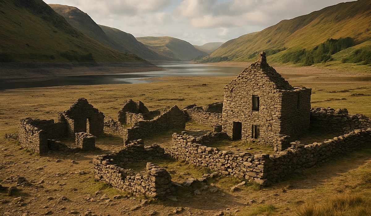
Image generated by AI
A Lost Village Emerges from the Water
Mardale Green, a stone-built settlement submerged beneath Haweswater Reservoir since 1936, has resurfaced across England's historic Lake District as record-low water levels expose the drowned community. Dry conditions during March 2026 have pushed the water line dramatically lower than normal, revealing dry stone walls, bridge abutments, and building foundations that trace the footprint of a once-thriving village in Cumbria's remote Mardale Valley. This rare emergence offers travelers and history enthusiasts an extraordinary opportunity to walk across ground that has remained underwater for nearly nine decades, witnessing firsthand the physical traces of a community sacrificed for regional water security.
How Manchester's Water Demand Flooded a Valley
The transformation of Mardale Green from agricultural settlement to submerged archaeology began in the 1920s. Manchester Corporation identified the Mardale Valley as an ideal location for a major reservoir to supply drinking water to growing industrial cities across northwest England. Parliamentary approval in 1929 authorized construction, and between 1929 and 1935, engineers completed a concrete dam that would alter the landscape permanently. The completed structure raised water levels by approximately 30 meters, inundating farmsteads, stone cottages, and the village inn. Local heritage records indicate that Mardale Green's church was systematically dismantled, with stone and windows salvaged for use in reservoir infrastructure. By 1939, the last residents had departed, and the historic Lake District location had transformed into a strategic utility asset. Today, Haweswater supplies water to thousands of households and businesses across the region, making this sacrifice foundational to modern regional infrastructure.
The Ghostly Architecture Beneath the Surface
When water levels fall at Haweswater, the 2026 drought has revealed structures with striking clarity. Visitors exploring the exposed reservoir bed report finding dry stone field boundaries, gateposts, and sections of former lanes that once connected farmsteads throughout the valley. The outline of the village bridge is particularly visible during low-water periods, allowing people to retrace historic routes and understand the settlement's layout. Previous resurfacing events in the 1970s and 1980s documented similar features, but heritage organizations note that the current exposure ranks among the most comprehensive in recent years. The structures tell stories of deliberate agricultural planning, with evidence of field systems and trackways showing how Mardale's residents managed their pastoral landscape. Local history groups maintain extensive photographic records comparing pre-inundation images with contemporary observations, creating a living archive of comparison. Visitors can download heritage guides from Lake District National Park Authority to contextualize their observations and understand the architectural styles and village layout.
Changing Climate Patterns and Reservoir Resilience
Water-resource analysts project that drought events revealing submerged landscapes may become increasingly frequent across the historic Lake District. Climate data suggests that precipitation patterns are shifting, potentially creating longer dry periods that lower reservoir levels more dramatically than in previous decades. Haweswater's current status as a sensitive indicator of regional drought stress means that future years may offer additional windows to observe Mardale Green's ruins. The 2026 resurfacing reflects broader water-management challenges facing England's northwest region, where aging infrastructure and variable weather patterns create competing pressures between heritage preservation and essential water supply. Resilience specialists recommend that water utilities and local planners develop integrated strategies that balance conservation concerns with supply reliability. Research from the University of Manchester's water resources department indicates that strategic reservoirs like Haweswater will play critical roles in climate adaptation, even as their environmental legacies invite ongoing historical and ethical reflection.
Visitor Access and Heritage Conservation at Haweswater
The resurfacing of Mardale Green has attracted hikers, photographers, and history enthusiasts from across the United Kingdom and beyond. Regional tourism authorities report increased foot traffic to the historic Lake District location during March and April 2026. However, conservation guidance emphasizes that exposed ruins remain fragile and require respectful treatment. Visitors should stay on established paths where possible and avoid disturbing stone foundations or walking carelessly across soft, silty ground adjacent to the water line. Water utilities managing Haweswater remind visitors that the reservoir remains fully operational and that water levels can change rapidly, even during drought periods. Restricted zones exist around dam infrastructure and water-intake facilities, and trespassing in these areas carries legal penalties. Heritage bodies have published guidance documents available at visitor centers recommending that people avoid removing artifacts or marking historic structures. For travelers planning a visit, the Lake District National Park website provides current access information and seasonal guidance for exploring this extraordinary historical site.
The Broader Narrative of Sacrifice in British Water Infrastructure
Mardale Green's story reflects a wider pattern of communities displaced during Britain's twentieth-century water engineering expansion. Across England and Wales, dozens of villages were deliberately flooded to create reservoirs serving growing urban populations. Archival records and local histories document the human costs of these projects: families relocated, churches demolished, burial grounds exhumed, and agricultural traditions erased. The resurfacing of Mardale Green at Haweswater prompts contemporary reflection on how societies balance resource security against heritage preservation and cultural memory. Heritage organizations regularly cite the historic Lake District village as a case study in infrastructure ethics, particularly as climate change heightens pressure on water supplies. Visitors observing the exposed walls and foundations gain visceral understanding of the deliberate choices embedded in Britain's landscape. The temporary return of Mardale Green serves as a poignant memorial to the balance between progress and loss that characterizes modern resource management.
Key Data: Mardale Green and Haweswater Reservoir
| Feature | Details |
|---|---|
| Village Name | Mardale Green, Mardale Valley, Cumbria |
| Inundation Date | 1936 (water level reached full capacity) |
| Time Submerged | Approximately 90 years as of March 2026 |
| Water Level Rise | Approximately 30 meters above original valley floor |
| Dam Completion | 1935 |
| Reservoir Authority | United Utilities (successor to Manchester Corporation) |
| Primary Supply Region | Northwest England (Manchester area and surrounding authorities) |
| Visible Structures | Dry stone walls, bridge abutments, building foundations, field boundaries, gateposts |
| Previous Resurfacing Events | 1970s drought, 1980s drought, intermittent low-water periods |
| 2026 Water Level Status | Record lows during March due to sustained drought conditions |
| Heritage Protection Status | Scheduled Ancient Monument and protected historic environment |
What This Means for Travelers
-
Timing Matters: The current 2026 resurfacing window has limited duration. As rainfall increases, water levels will gradually rise, re-submerging Mardale Green's exposed features. Plan a visit soon if you wish to observe the ruins firsthand, but check current weather forecasts and reservoir status before traveling.
-
Practical Preparation: Wear sturdy waterproof hiking boots suitable for soft, silty ground. The exposed reservoir bed contains areas of mud and unstable earth. Bring a camera with good zoom capability to photograph distant features safely. Consider downloading offline maps and heritage guides before visiting.
-
Respect Heritage Boundaries: These are remains of real people's homes and burial ground. Treat all structures with reverence. Do not remove artifacts, mark stones, or disturb soil. Several areas remain restricted due to dam infrastructure; obey all signage.
-
Safety Awareness: Reservoir water levels can change without notice, even in dry periods. Never venture to the water's edge
Disclaimer
This article is for informational and educational purposes only. It does not constitute legal, financial, or professional advice. While we strive to provide accurate and up-to-date information, travel policies, regulations, and conditions change rapidly. Always verify information with official sources before making travel decisions. Nomad Lawyer makes no representations about the accuracy, reliability, completeness, or suitability of the information provided. Readers should consult qualified professionals for advice specific to their circumstances. The views expressed in this article are those of the author and do not necessarily reflect the views of Nomad Lawyer.

Kunal K Choudhary
Co-Founder & Contributor
A passionate traveller and tech enthusiast. Kunal contributes to the vision and growth of Nomad Lawyer, bringing fresh perspectives and driving the community forward.
Learn more about our team →