
Is Sargassum Ruining Belize Vacations? What Travellers Need to Know Before Booking
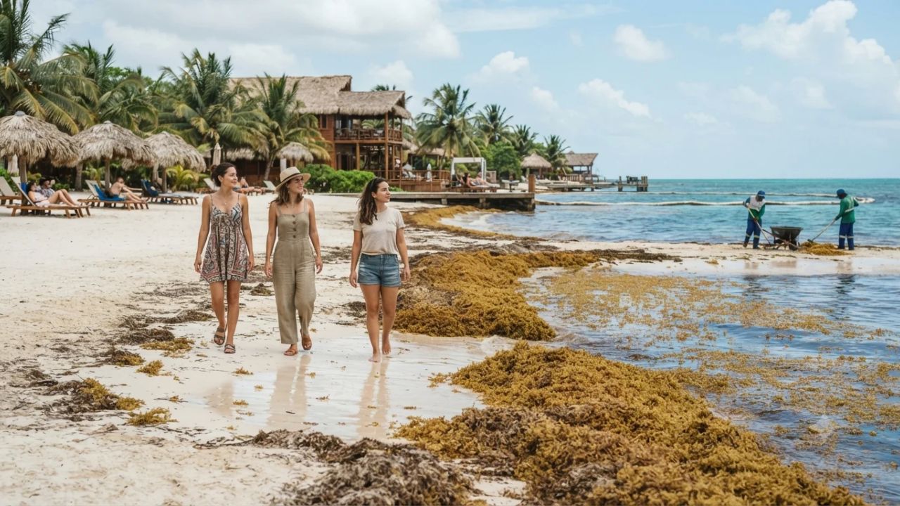
Image generated by AI
While thick windrows of rotting brown seaweed regularly blanket the resort shores of San Pedro and Placencia, the offshore waters around the Great Blue Hole, Turneffe Atolls, and Lighthouse Reef remain as gin-clear and sapphire-blue as ever. Because pelagic sargassum floats strictly on the open oceanic surface before prevailing easterly trade winds push it against mainland beaches, travelers who venture just a few miles beyond the coast discover that Belize's underwater wonderland is operating completely uninterrupted. Understanding this geographical divide is what separates an exasperated vacationer from a savvy explorer who knows how to navigate Central America's premier marine sanctuary.
The Golden Tide Dilemma: How Sargassum Is Reshaping Belizean Coastal Travel
Over the past decade, pelagic sargassum macroalgae has shifted from an occasional seasonal curiosity into a persistent regional challenge spanning the wider Caribbean basin. Originating from the Sargasso Sea and the expansive Central Atlantic Belt, massive floating vegetative mats are pushed westward into Central American waters. When these dense accumulations reach land, coastal hotspots including San Pedro on Ambergris Caye and Placencia in the Stann Creek District face relentless cycles where mounds of seaweed wash ashore overnight.
Oceanographic research from the University of South Florida Optical Oceanography Lab and local marine monitoring teams indicates that this surge stems from a convergence of climatic and human factors. Rising sea surface temperatures, altered wind patterns, and nutrient enrichment from deforestation and agricultural fertilizer runoff discharging through major river systems like the Amazon and Orinoco feed intense blooms across open ocean waters. While biomass levels fluctuate throughout the year, satellite tracking shows that baseline quantities remain elevated year-round.
For coastal tourism, the implications are tangible. Decomposing seaweed along beaches releases a pungent hydrogen sulphide gas odour, while physical barriers of brown algae hinder shoreline wading and swimming. In response, resorts and municipal councils have deployed mechanical collection machines, specialized skimmer vessels, and daily manual raking teams to maintain clear swimming corridors. Yet travelers expecting postcard-perfect beachfronts right outside their hotel suites must recognize that nature in the tropics operates on dynamic biological cycles.
What Makes Belize Different: The Outer Atoll Sanctuary and Dual-Ecosystem Advantage
Belize possesses a geographic advantage that many regional beach destinations lack: the Belize Barrier Reef Reserve System, designated as a UNESCO World Heritage site for its extraordinary marine biodiversity. Stretching parallel to the coast, the barrier reef acts as a natural buffer. While mainland coastlines and windward island shores catch wind-driven seaweed, the outer atolls remain situated beyond the primary deposition pathways.
Travelers who charter dive boats or book stays on remote atolls—including Turneffe Atolls, Lighthouse Reef, and the legendary Great Blue Hole—step into pristine waters untouched by shoreward accumulation. Visibility beneath the surface frequently exceeds 100 feet, where nurse sharks, spotted eagle rays, and vibrant coral heads thrive in clear currents. The problem of sargassum is essentially a shoreline dilemma, not a deep-water diving limitation.
Equally distinctive is Belize's dual-ecosystem layout. Unlike low-lying coral sandbars in other parts of the Caribbean, Belize boasts an expansive, wild interior just an hour or two from the coast. When onshore winds bring heavier seaweed deposits to the shoreline, travelers effortlessly pivot inland to the lush Cayo District. Here, ancient Maya ruins like Xunantunich and Caracol rise above dense rainforest canopies, while network caves offer subterranean cave-tubing expeditions and wildlife reserves shelter howler monkeys, toucans, and tapirs.
Visitor Insider Tips
Seasonal Timing and Algae Forecasting
Historically, sargassum influxes reach their highest volumes between April and August, when ocean temperatures peak and easterly trade winds blow consistently. If your goal is seaside relaxation, target visits during the late autumn and winter months, from November through February, when cold fronts from the north temporarily disrupt easterly drift patterns. Always check real-time satellite forecasts and verify with your resort whether they maintain active offshore barrier booms or daily shoreline clearing crews before confirming dates.
Local Etiquette and Marine Conservation Customs
Belizeans maintain deep reverence for their marine environment and expect visitors to share that commitment. When wading or boating near the barrier reef, use strictly mineral-based, reef-safe sunscreen free of oxybenzone and octinoxate to prevent coral bleaching. Avoid touching sea life or standing on living coral beds during snorkeling excursions. On the cayes, patience is valued; respect the strenuous physical labor of local hospitality workers who shovel seaweed at sunrise to keep private beaches clear for guests.
Coastal Garifuna and Creole Flavors
Step away from resort buffets to taste authentic coastal cuisine unimpacted by oceanic conditions. In Placencia, seek out traditional Garifuna hudut—a rich, savory stew of fresh snapper poached in coconut milk and crushed plantains seasoned with garlic, cilantro, and habanero. In San Pedro, sample Creole-style stewed chicken with red beans and coconut rice, freshly caught lionfish ceviche marinated in lime juice, and sweet cassava bread baked fresh in family kitchens.
Island Hopping and Inland Transit Strategies
To maximize your vacation, split your itinerary between the coast and the jungle. Base yourself on the leeward side of Ambergris Caye or Caye Caulker, where sheltered lagoons and western beaches experience significantly less seaweed buildup than exposed eastern coastlines. For travel between coastal hubs and the interior, domestic flights via regional puddle-jumpers connect San Pedro and Placencia to Belize City in under 30 minutes, allowing swift overland transfers toward the Cayo District's river valleys. Authoritative travel planning advice is curated through the Belize Tourism Board.
Cultural and Environmental Context: Coastal Ecology, Circular Economies, and Maya Heritage
Managing sargassum has evolved into a vital community-wide effort balancing conservation, economic viability, and public health. The Belize Tourism Board (BTB), working alongside the Department of the Environment, provides operational guidelines and logistics support to help municipal authorities clear shorelines without damaging coastal dune habitats. Indiscriminate heavy machinery can cause beach erosion, prompting coastal communities to prioritize manual labor and floating ocean deflection booms.
Concurrently, Belizean innovators and academic researchers are transforming this oceanic burden into economic potential. Rather than hauling decaying biomass to landfills, where heavy metals could leach into freshwater tables, emerging circular-economy ventures are processing harvested sargassum into organic agricultural fertilizers, nutrient-rich compost, and biodegradable packaging materials.
In the interior, indigenous Maya communities and local conservationists preserve centuries of forest knowledge, stewarding sacred rivers and archaeological parks that provide sustainable livelihoods independent of maritime conditions. By distributing their travel spend between coastal dive operators and inland forest communities, travelers directly support a diversified economy capable of withstanding ecological variability.
FAQ: Visiting Belize 2026
Can you still swim and snorkel in Belize when sargassum is present?
Yes. Outer atolls like the Blue Hole, Lighthouse Reef, and Turneffe Atolls remain completely clear. Additionally, leeward island shores and resort pools offer pristine swimming regardless of coastal seaweed drifts.
What months have the highest sargassum levels in Belize?
Sargassum deposits traditionally peak between April and August due to warmer ocean temperatures and stronger trade winds, though shifting Caribbean currents mean small volumes can appear throughout the year.
How does inland Belize provide an alternative to the beaches?
The inland Cayo District features ancient Maya temples, subterranean cave-tubing rivers, and dense rainforest reserves, providing immersive adventure travel completely free from coastal marine algae.
What mitigation measures are Belizean resorts using against seaweed?
Properties utilize floating offshore containment booms to deflect incoming seaweed, specialized ocean skimmer boats, and dedicated morning raking teams to maintain clear shoreline corridors for guests.
Beneath the sweeping Caribbean sun, Belize proves that an extraordinary journey is defined by the depth of your curiosity rather than the state of the tide.
Related Travel Guides
Mexico Tourism Surge and Sargassum Travel Advisory Trends
Disclaimer
This article is for informational and educational purposes only. It does not constitute legal, financial, or professional advice. While we strive to provide accurate and up-to-date information, travel policies, regulations, and conditions change rapidly. Always verify information with official sources before making travel decisions. Nomad Lawyer makes no representations about the accuracy, reliability, completeness, or suitability of the information provided. Readers should consult qualified professionals for advice specific to their circumstances. The views expressed in this article are those of the author and do not necessarily reflect the views of Nomad Lawyer.
Kunal K Choudhary
Co-Founder & Contributor
A passionate traveller and tech enthusiast. Kunal contributes to the vision and growth of Nomad Lawyer, bringing fresh perspectives and driving the community forward.
Learn more about our team →